B&G
B&G-000-11244-001-ZEUS²7 Multi-function Display, World Base Map.
B&G-000-11244-001-ZEUS²7 Multi-function Display, World Base Map.
Couldn't load pickup availability
Zeus² 7

The B&G Zeus² 7 is an easy to use, ultra-responsive chartplotter designed specifically for sailors. It is packed with exclusive B&G sailing features including:
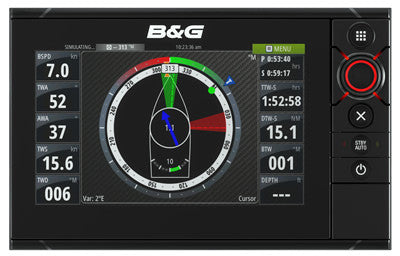
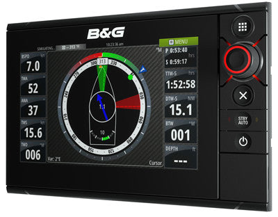
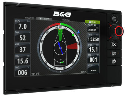
SailSteer - all your sailing data on one display
Laylines - view tacking angles on the chart even without an active waypoint
RacePanel - allows easy access to a selection of powerful sail racing features including: Start Line & What If?
In addition integrated GoFree™ enables wifi connectivity for direct chart and software update download.
The Zeus² 7 has a highly intuitive and responsive user interface with a multi-touch widescreen with pinch to zoom gestures - all backed up by B&G’s signature rotary controller. From the ultra-fast processor, which offers seamless chart redraw and super sharp graphics, to the bonded glass, bright LED backlit screen, every inch of the Zeus² has been engineered to provide style and sailing performance in the toughest of environments.
- Pioneering design
- Intuitive, responsive multi-touch display
- Choice of leading cartography options
- GoFree™ Wireless Technology
- Internal high-sensitivity GPS antenna
- Broadband Radar™ compatible
- Low power consumption
- Video input
- Integrated Pilot control
- NMEA 2000, 0183 and Ethernet compatibility
System wide software updates by interrogating a network and detecting if there is out of date software. When the MFD is connected to the Internet via a WIFI-1 module, this version can now download update files directly from the internet onto the memory card of the Zeus2 and then can update devices* over the Ethernet or NMEA 2000 network.
*Note: Other MFDs on the network are not updated across the network. Update using the memory card or connect other MFDs to the Internet. Not all products support this upgrade method. See below for a list of supported products that can be updated. More products will be added in the next release.
Overview
| Display Size | 7” / 178mm Widescreen 16:9 |
| Resolution | 800 x 480 |
| Backlighting | LED / 1200 nits |
| Operating Voltage | 9-32V DC |
| Media Port | 2 x microSD |
| Warranty | 2 Years (3 Years with +1 Advantage) |
Display
| Display Resolution | 800 x 480 |
| Display Type | WVGA Colour TFT LCD |
| Display Backlighting | Enhanced LED |
| Backlighting Levels | 1200 nits |
| Display Size | 7”/ 178mm |
Technical/Environmental
| Waterproof Standard/Rating | IPx7 |
| Product Width | 231.5mm |
| Product Depth | 105.6mm |
| Product Height | 147.2mm |
Power
| Power Supply (Supply Voltage) | 9-32V DC |
GPS Navigation
| Navigation | Waypoint Storage: 10,000 points total combined waypoints / route points |
| GPS Antenna Type | 10Hz High Gain built-in GPS |
| Background Mapping | Embedded World Background map. Provided with blank media for Navionics® or C-MAP MAX-N online download |
| Mapping Options | Navionics®, C-MAP MAX-N, Insight, Insight Genesis, NV Digital and charts produced with Navico Mapcreator |
Networking Connectors
| NMEA 0183 Output | GGA, GLL, GSA, GSV, VTG, ZDA, AAM, APB, BOD, BWC, BWR, RMC, XTE, DBT, DPT, MTW, VLW, VHW, HDG, MWV, TLL, TTM |
| NMEA 2000 connection | Yes |
| Ethernet Connection | Yes |
Other
| Languages | English(US), English(UK), Danish, German, Spanish, Finnish, French, Greek, Icelandic, Italian, Dutch, Norwegian, Portuguese, Swedish, Japanese, Korean, Thai, Chinese, Bulgarian, Hebrew, Croatian, Hungarian, Lithuanian, Latvian, Polish, Slovak, Turkish, Russian, Ukrainian, Arabic, Farsi (some languages require optional language packs) |