

Lowrance
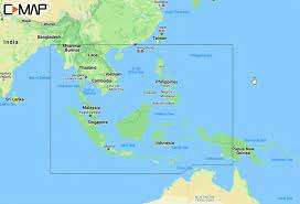
C-MAP M-IN-Y203-MS MAX-N+ Chart Thailand Malaysia West Indonesia
C-MAP M-IN-Y203-MS MAX-N+ Chart Thailand Malaysia West Indonesia
Couldn't load pickup availability
C-MAP MAX-N+ Wide Chart – Thailand, Malaysia & West Indonesia (M-IN-Y203-MS)
The C-MAP M-IN-Y203-MS is a high-performance MAX-N+ Wide Electronic Marine Cartography Card engineered specifically for Navico multi-function displays (Lowrance, Simrad, and B&G). Covering the key coastal routes and waterways of Thailand, Malaysia, and West Indonesia (including the Malacca Strait, Andaman Sea, and Gulf of Thailand), it provides comprehensive navigation and angling data derived from official hydrographic office surveys.
Built on C-MAP’s MAX-N+ platform, the card features full-featured vector charts, High-Resolution Bathymetry (HRB) layer, dynamic raster charts, aerial photos, and detailed marina/port plans. Advanced digital features such as Custom Depth Shading and Easy Routing™ assist captains, cruisers, and saltwater anglers in auto-plotting safe navigation paths and targeting key underwater structures.
Key Features
-
Full-Featured Vector Charts: Delivers up-to-date vector chart details, buoyage, bathymetric contours, and official navigational hazards.
-
High-Resolution Bathymetry (HRB): Detailed depth contour lines allow anglers to pinpoint drop-offs, ledges, holes, and humps.
-
C-MAP Easy Routing™: Automatically calculates the safest and shortest route based on vessel draft, beam, and height constraints.
-
Custom Depth Shading: Allows users to set safety depths or customize color ranges for easy seabed visualization.
-
Detailed Marina Port Plans & Aerial Photos: Features precise layouts of docks, slip spaces, channels, and restricted zones for safe mooring.
Request a quote
Requesting a quote for C-MAP M-IN-Y203-MS MAX-N+ Chart Thailand Malaysia West Indonesia
Thank you. We received your request and will get back to you soon.